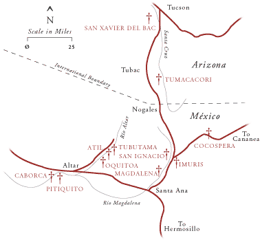


Tucson
The Santa Cruz Valley was
originally settled by Spaniards as part of a system of
missiones and visitas under Padre Kino in the early 1700s.
In 1744 and 1747 the Spanish king approved advancement of
the military frontier to the Gila River in response to the
threat of French expansion westward from the Gulf of Mexico,
and presidios were established in the Alta Pimerfa. The
presidio at Tubac was one of these, situated some thirty
miles south of the present-day site of Tucson. It had a
combined military and civilian population of about 500 in
the 1760s. In 1772 instructions were received from the
viceroy to relocate the presidio to Tucson; it is a
reflection of the scarcity of funds and personnel that this
was not accomplished until 1776, and further, that the
presidio walls were not completed until 1782. The presidio
was approximately three hundred years on a side, bounded by
twelve-foot-high adobe walls three feet thick at the base.
it had a single gate centered on the west side, around which
the first civilian settlement grew up. The interior of the
presidio was split by a row of buildings into two plazas,
with military stores and quarters built along the outer
walls. This pattern was maintained after the wafls came
down. In 1791, in an effort to induce further settlement of
the area, the governor of the Provincias Internas set aside
four square leagues around each presidio for civilian
settlement (Mattison 1946:281). In fact, this had little
impact outside of the area immediately around the presidio;
like the Rio Grande settlements, the outlying Santa Cruz and
San Pedro ranches were subject to frequent attacks by Apache
Indians, and there was thus little incentive to settle
beyond the safety of the presidio.
In 1821, Tucson had a
population of about 1,100 persons, approximately 500 of whom
were Spaniards (Sonnichsen 1982:26). They occupied an area
of less than two square miles and were engaged primarily in
subsistence agriculture and stock raising. In his narrative
history of Tucson, C. L. Sonnichsen describes the town in
the following way:At the end of the Spanish period, just
before the revolution of 1821, Tucson was a moderately
prosperous village in which Spaniards and Indians lived side
by side, but the native population was slowly giving way to
Hispanics and mixed-bloods. Retired soldiers were occupying
fields which once belonged to the Papagos, though they were
not allowed to take possession of the lands controlled by
the mission. Other Spaniards had come up from the south in
response to the settlement law of 1791. . . . There was
trouble between mission Indians and settlers, giving a
preview of problems that were to plague the community for
many years to come. (Sonnichsen 1982:27)
During the three
decades of Mexican administration, Tucson experienced a
general decline–the economy was disrupted by Apache raids,
the mission was weakened by secularization in 1828, and the
Indian population was reduced by disease and a declining
birthrate.
The first Americans who came to Tucson
during this period were trappers looking for beaver along
the Gila and Santa Cruz rivers in the 1820s. The "Mexican
War" in 1846 brought U.S. soldiers to the area, and when the
Gadsden Purchase was finalized in 1854 U.S. troops took
charge of the garrison, bringing with them Anglo settlers
who could make a living serving the military's needs.
Sonnichsen describes the period from the mid 1850s through
the American Civil War as "the great transition" in Tucson's
history: a transition related to developing communication
and transportation linkages to the rest of the United
States. The first mail routes became dependable at the end
of the 1850s, the regular arrival and departure of
stagecoaches (at 1:30 P.m. on Tuesdays and Fridays for
westbound mail and passengers, and at 3:00 A.M. on
Wednesdays and Saturdays for eastbound coaches) imparted a
new rhythm to the town's life, where contact with the
outside world had been limited to infrequent and
intermittent military and government-controlled commercial
expeditions (Sonnichsen 1982:43).
Stagecoaches were
followed by wagon trains as the number of California
immigrants choosing to take the southern route through
Tucson rose. This was a period of economic growth for the
town; the mines in the region became active again, and there
was an increase in the number of military and Indian Agency
personnel whose needs generated a corresponding increase in
trade. The population doubled between 1850 and 1860–the
census of the latter year counted 623. By 1858 there were
three general stores, two butcher shops, and two
blacksmiths; 1859 saw the first saloons, and a gristmill on
the Santa Cruz; and by 1869 there was even a brewery and
beer garden established by a German immigrant (Sonnichsen
1982:59).
The business center of Tucson was Calle de
Correo, renamed Pearl Street in the Anglo Territorial
period. The original name indicates the location of the post
office; opposite that was the Buckley House complex, which
provided accommodations for travelers and horses, as well as
storage for merchandise prior to sale. Contiguous with the
Buckley House complex was Pacheco's blacksmith shop and
residence. The courtyard complex occupied on one side by the
post office contained a store on the side fronting Calle
Real, later Main Street (Sonnichsen 1982:43).
The
irregular pattern of this settlement derives in part from
Tucson's origin as a presidio, which occupied the
approximate square containing the Plaza Militar and Plaza de
las Armas in Fergusson's 1862 map (fig.22). The civilian
community established itself just outside the main gate,
within a bend in the acequia serving the presidio. This
growth was not governed by the Laws of the Indies; lacking a
plaza as a generator of form, buildings grew along
established routes of travel between the presidio, the
river, and the mission. The initial southerly offset (with
respect to the gate) began a pattern of development that
shifted southward around the edge of the old presidio,
between its plaza and the Plaza de la Mesilla. Analysis of
the 1883 Sanborn map shows the greatest density centered
around Pennington and Congress and around Main and Meyer
streets.
The Sanborn map of 1883 also shows that the
initial business area west of the presidio gate underwent a
cultural "replacement" process as well as a physical one:
the uses indicated on the Sanborn map are "Chinese Laundry,"
"Chinese Opium Den," and "Chinese Grocery." There had been
Chinese in Tucson since the 1860s; when the railroad was
completed in 1880, a group settled in this part of town and
had developed more than one hundred acres of truck gardens
along the Santa Cruz floodplain by 1884. Pacheco's
blacksmith shop was altered by the addition of a new row of
rooms behind the first, to accommodate the "lodging house"
for Park Brewery, part of the new "entertainment district"
west of the acequia.
Tucson was incorporated as a town
in 1874, occupying two complete sections; streets and blocks
were laid out parallel to the section lines, and the street
numbers began on the eastern section line–rather than at the
center of town–an indication of the power of the survey grid
as a tool to rationalize the landscape.
The 1870s saw
the first public school, and as a consequence, a first small
influx of unmarried Anglo women. Up until this time Anglo
merchants often married Hispanic women, thereby assuring
cultural assimilation, and in the case of those who married
into wealthy families, access to the important social and
economic network. The availability of Anglo women in the
community marked the beginning of an important cultural
shift. Sonnichsen notes that intermarriage became less
frequent throughout the 1870s and 1880s and that newspaper
accounts of social events contained fewer and fewer Hispanic
names (Sonnichsen 1982: 88). Although a cause-and-effect
relationship would be difficult to document, one can
speculate that these Anglo women began to transform their
environment at the smaller scale levels. Certainly their
attitudes are well known through the diaries they kept
(Susan Magoffin's diary of her travels and time in Santa Fe
during the 1840s is the best-known example). The adobe house
with its dirt floors, whitewashed walls, and dirt roof,
which needed constant attention to maintain, seemed
primitive to Anglo women used to raised wood floors, glass
windows, and painted or papered walls. Beginning with their
inundated environment, the house interior, transformations
occurred at the detail level–rooms were filled with
furniture brought by wagon from the East or Midwest, glass
windows and trim were installed in existing openings or new
ones, wood boards covered dirt floors–such transformations
all fall under the category of addition.
While some
prosperous Anglo and Hispanic families continued to live in
and transform their courtyard houses, others constructed new
houses at the earliest opportunity. These houses constituted
additions at the district level, new houses inserted into
the existing fabric. The residence of Anglo families in
Tucson also created the need for certain related
institutions. By the 1870s there were three schools,
Methodist and Episcopal churches, a hospital (although this
was Catholic), and a public bathhouse. These buildings
represent addition and infill at the district level; they
appear as isolated structures unrelated in form to their
Hispanic environment. Infill at the district level can be
observed in the circa 1880 photograph of the Plaza de las
Armas (fig. 23), where a church and landscaped park now
occupy the former plaza, and a two-story house with bay
windows has been built on the north side of the plaza. None
of these elements follows the formal rules of Spanish and
Mexican town form, such as continuous street facades (no
set-backs), flat roofs, and open plaza (fig. 24).
Not
all of these transformations occurred at the district level:
some buildings were reconfigured or added to as a result of
the cultural shift. An example was the Cosmopolitan Hotel on
the comer of Pennington and Main. An 1874 photograph shows
an adobe structure with a heavy portal, and a subsequent
photograph of the same building, rechristened "The
Orndorff," shows that one wing of the building has added to
it a frame second floor and balcony, complete with bracketed
cornice (Sonnichsen 1982: 100, 101). A photograph of Meyer
Street in the 1880s (fig. 25) shows the addition of several
simple porches and at least one brick parapet coping.
Anticipation of the approaching railroad led to a boom in
real estate values in the late 1870s; when the first train
actually arrived on March 20, 1880, "prices on practically
everything were rapidly revised downward," causing the
financial ruin of several of Tucson's most prosperous
merchants (Sonnichsen 1982:105). Five concerns either sold
off stock to their creditors or went bankrupt in the
following four years. This loss, however, was limited in
scope, and in the long run the railroad only hastened
economic and population growth in Tucson.
The new
railroad tracks and depot one-half mile from the business
center sprouted a district of warehouses and shops. Congress
Street developed as a connection between these two areas,
and as Sonnichsen notes, "it was the first east-west
thoroughfare to break the old north-south pattern"
(Sonnichsen 1982:107). Unlike Albuquerque and Las Vegas,
where the orientation of the railroad tracks dictated the
street orientation of the "new town," the diagonal path of
the railroad through Tucson simply broke through the grid of
blocks and streets, with the exception of Toole Avenue and
the lots fronting the railroad.
An increase in Anglo
population relative to Hispanic population resulted in an
increase in the pace of environmental change. In 1882, the
Arizona Citizen described the "change in building styles"
due to replacement of adobe with brick and lumber, observing
that "newcomers preferred to freeze in winter and stew in
summer rather than live in one of those 'ugly mud houses.'
The idea of stepping through one's front door into the
street was equally repugnant, and in the new districts a
front yard interposed a decent interval between residence
and road.... New residents (also) imported the green lawn"
(Sonnichsen 1982:107). Wealthy residents built northward on
Main Street, their large houses bringing Eastern
architectural styles and materials to the desert setting.
Reinforcing these directional trends was the location of the
university in 1891. Three businessmen donated forty acres
one-half mile northeast of the railroad depot, creating an
impetus for the development of new residential
neighborhoods. The first additions to the original
two-square-mile townsite after the turn of the century were
in this direction.
These initial trends of growth for
the Anglo population to the north and east signaled future
patterns: the predominantly Hispanic neighborhoods and the
incorporated town of South Tucson remain in the southern
sectors of the metropolitan area, while the wealthy Anglo
population has leapfrogged to successively higher and higher
around in the foothills of the Tucson, Santa Catalina, and
Rincon mountains to the northwest, north, and northeast,
respectively.
One example of infill at the city level is
the subdivision of the Old Military Plaza (fig. 26), now
known as the Armory Park neighborhood. It was laid out in
the same pattern of regular lots (50 ft. x 150 ft.) that was
used in the rest of the town and built in the Anglo pattern
of "solid" volumes in the center of open but private
territory; again, the antithesis of the Hispanic pattern of
building enclosing private open space (courtyard).
As
the business district expanded along Main and Meyer streets,
it displaced Mexican American families who, according to
Sonnichsen, were either bought out or forced out; they moved
southward, concentrating around the Plaza de la Mesilla,
renamed Church Square (fig. 27). Adjacent to this area on
the north in the 1890s was Tucson's "sporting district,"
occupying a narrow,, tapering block called "The Wedge." The
Wedge provided Tucson with its first opportunity for
demolition at the district level when it was razed in 1902
in combination with other street-widening work, which
constituted overall reconfiguration at that level.
In
the last two decades of the century additions were made to
the urban infrastructure. The privately owned Tucson Water
Company began operating in 1882, marking the end of private
wells and of a part of the service sector of the economy:
water carriers had sold in the plaza buckets of water
brought from the Santa Cruz for five cents. The city took
control of the water system in 1890, coinciding with work on
a sewer system. An 1881 proposal for streetcars was not
implemented until 1898, when mule-drawn cars went between
downtown, the train depot, and the new university. The mules
were replaced by electricity in 1906.
As early as the
1880s Tucson began to see tourists and health-seekers
arriving for the winter months. By the turn of the century
this influx had grown tremendously, facilitated by good
passenger rail service and increasing private ownership of
the automobile. Tucson actually experienced a housing
shortage in the 1890s as tuberculosis patients camped in
tent cities at the edges of town and in the Santa Catalina
Mountains (Sonnichsen 1982:141). In spite of this, the
city's growth was by no means assured. "Indian problems"
continued into the mid 1880s, when the last rebel Apaches
conducted their campaign of resistance to Anglo control from
mountains in southeastern Arizona. Population in Tucson
actually fell between 1880 and 1890 but then began a rapid
rise, reaching 13,000 by 1910 (Sonnichsen 1982:210).